

Before dawn on 10 June 1886, Mount Tarawera split open along a rift 17 kilometres long and destroyed the Pink and White Terraces, the two silica staircases on the shore of Lake Rotomahana that had made the Rotorua lakes the place where, as the Rotorua Museum puts it, tourism in New Zealand was born. Around 120 people died, nearly all of them Māori. The lake itself was blown out of the ground. Within a generation a new and far larger lake had filled the crater, and the argument over what lies beneath it has never really stopped.
This piece goes back to the people who saw the terraces with their own eyes and wrote it down. The Austrian geologist who surveyed them in 1859, the English novelist who bathed in them in the 1870s, the historian who saw them shortly before they vanished, the painter who camped beside them for six weeks, the guide who ran the tours, and the officials who wired the first news of the eruption. It then follows the scientific search that began in 2011 and, as of 2026, still has not settled where the terraces are.

What the terraces were
Ferdinand von Hochstetter arrived in New Zealand with the Austrian Novara expedition on 22 December 1858 and set out for Lake Rotomahana on 28 April 1859. His account, published in English in 1867 as New Zealand: its physical geography, geology and natural history, is what NIWA describes as the only known formal survey of the lake made before the eruption, and it is candid about first impressions. He wrote that “the small, dirty-green lake” with its marshy shores and dreary treeless hills did not correspond to the expectations a traveller had formed from hearing so much about it.
Then he measured it. The old Rotomahana was not quite a mile long from south to north and only a quarter of a mile wide, sitting by his reckoning 1,088 feet above sea level. It was warm because boiling water welled up from the shores and the lake bed. At the north-eastern end, about 80 feet above the water, sat Te Tarata, the White Terrace. Its spring basin was about 80 feet long, filled to the brim with water Hochstetter measured at 183 degrees Fahrenheit at the margin and probably boiling in the middle. The name, he wrote, was said to mean “the tattooed rock”.
The overflow from that basin had built the terraces down the hillside, covering about three acres. Hochstetter wrote that they were “as white as if cut from marble” and that the whole thing had “the appearance of a cataract plunging over natural shelves, which as it falls is suddenly turned into stone.” Each semicircular step held pools of blue water, warmer on the higher steps and cooler below, which he described as “natural bathing-basins, which the most refined luxury could not have prepared in a more splendid and commodious style.” He summed it up in a sentence. “Such is the famous Tetarata.”
On the west shore was Otukapuarangi, the Pink Terrace, which he treated as the companion piece. Its platform sat about 60 feet above the lake and was 100 yards long and as wide, with basins three or four feet deep at 90 to 110 degrees Fahrenheit, and above it a spring cauldron 40 to 50 feet across at 179 degrees. He judged it not so grand as Te Tarata but neater and finer in structure, with a light pink hue. He recorded the name as meaning “cloudy atmosphere”, after the steam that never stopped rising from it.
The visitors
The visitors’ accounts quoted here are mostly about bathing. Anthony Trollope, whose account of New Zealand was first published in 1873 as part of his Australia and New Zealand, put the White Terrace at about 300 feet wide and nearly 200 feet high from the lake, and then crossed to the Pink Terrace to bathe as he had been advised. He wrote that four or five people could sport in one basin without feeling each other’s presence, and that “I have never heard of other bathing like this in the world.”
Lying in the water, Trollope also did something very Victorian. He planned a hotel. “The time probably will soon come in which there will be a sprightly hotel at Roto Mahana, with a table d’hote, and boats at so much an hour, and regular seasons for bathing,” he wrote, before worrying at length about how mixed bathing would be managed. He called the place “a spot for intense sensual enjoyment”.
The historian James Anthony Froude visited before the eruption, and his Oceana, published in 1886, records how the trade worked. The terraces were 24 miles off. Visitors drove to the village of Te Wairoa, slept there, and next day were taken by boat across Lake Tarawera by the tribe that owned the terraces. Froude’s party of three paid four pounds. “The tariff is fixed, to limit extortion,” he wrote, and the money went to the villagers. A guide, Kate, went with them. Sketching was prohibited unless it had been paid for, a rule Froude’s companion ignored. He had arrived expecting to be disappointed by “the eighth wonder of the world” and instead saw “a crystal staircase, glittering and stainless as if it were ice, spreading out like an open fan from a point above us on the hillside”.
The rule about sketching mattered to Charles Blomfield. According to his Dictionary of New Zealand Biography entry, the Auckland painter reached Rotomahana on 31 December 1875, found the terraces “exceedingly beautiful and graceful”, and managed a few pictures without being caught by the local people, who would demand five pounds for any drawing or photograph or destroy the sketches. In 1884 he came back, arranged through a friend, Charles Haszard, to pay a lump sum for as long as he liked, and camped and painted for six weeks with his eight-year-old daughter. After the eruption he realised the paintings were now a valuable record, refused to sell the originals, made scale copies instead, and returned in October 1886 to paint the devastation.
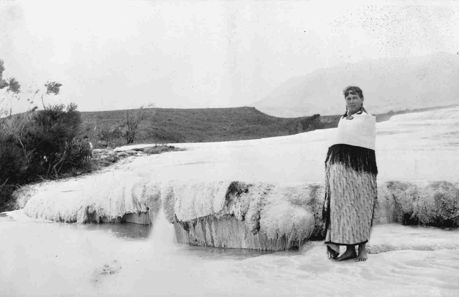
The guide who held it all together was Sophia Hinerangi. Her biography records that she had guided the terraces for about 16 years before the eruption, arranging the parties, settling the accounts and organising the other workers, and that as Guide Sophia she was the most famous woman in Rotorua. The Rotorua Museum says Te Wairoa had grown into a village of about 150 people on the strength of the trade, and that by 1860 Tūhourangi were organising day trips to the terraces.
The warnings
On 31 May 1886, ten days before the eruption by the calendar and eleven by Sophia’s own count, something happened on Lake Tarawera that was still being written about eighty years later. Sophia’s own description, as recorded in her biography, was that she first noticed an unusual rising of the lake, and then saw a phantom canoe that appeared small with one paddler, grew until it carried 13 occupants, and then shrank and disappeared. Te Ara notes that both Māori and European tourists reported the canoe and the surges in the water. The 1966 Encyclopaedia of New Zealand was careful to say that but for the tourists’ testimony the story would have remained just another legend.
Tūhoto Ariki, the elderly Tūhourangi tohunga at Te Wairoa, read the canoe as a warning. The Rotorua Museum records his words as “He tohu tērā arā ka horo katoa ēnei takiwā – it is a warning sign that all will be overwhelmed”. Te Ara’s account of Te Arawa says he feared the terraces were being exploited for tourism without regard to ancestral values. Apart from an increase in hot spring activity, there were no other warning signs.
The night of 10 June 1886
Te Ara’s reconstruction of the night runs like this. At Te Wairoa, 7.5 kilometres from the terraces, people were woken after midnight by earthquakes that grew more violent. Around 2am a fissure through Ruawāhia dome on Tarawera erupted. By 2.30am craters along the summit were throwing up fountains of glowing scoria and an ash cloud up to 10 kilometres high, lit by intense lightning. At 3.20am the explosions spread south-west, blasting craters through Lake Rotomahana and the Waimangu area. A rift 17 kilometres long was venting steam, mud and ash. By about 6am it was over.
Te Ara explains the mud this way. The eruption began as molten basalt, but when the magma met groundwater and the lakes the water flashed to steam and pulverised the ground, blasting it out as hot mud. A 2021 review in the New Zealand Journal of Geology and Geophysics puts the bulk volume erupted at 1.1 to 1.3 cubic kilometres, with the fissure active for about four hours, and describes it as one of the few basaltic Plinian eruptions on record, with tens of vents active along the rift. The same review gives the death toll as around 120, all but seven of them Māori, and says the entire populations of Te Ariki, Moura, Totarariki, Toiniho and Waitangi were lost, with a single exception.
The first news travelled by telegraph, and the Press in Christchurch printed the wires the next morning. At 8.52am the officer in charge at Rotorua telegraphed the Under-Secretary of Crown Lands. “We are in the midst of a terrible convulsion of nature.” The cones had burst into activity between one and two o’clock, thunder and lightning were incessant, dust and grit had reached Rotorua before six, the lake had risen and new springs had burst out, including a small geyser below his house. Many people had already cleared out for Oxford and Tauranga. The Rotorua postmaster wired that he had sent his family away, and “Hundreds of new boiling springs have broken out all round here, some in the middle of the road.”
By 9.18am the messengers he had sent to Te Wairoa were back with the first reports of casualties. The native schoolhouse had been struck by lightning and then overwhelmed with hot mud and stones. The schoolmaster, Haszard, and his family were reported dead apart from two daughters pulled through a window, though a wire at noon said Mrs Haszard had been rescued, injured. McRae’s Hotel was demolished and a tourist staying there was missing. By noon 14 Māori bodies had been recovered at Te Wairoa alone, and there was thought to be no hope for the settlements at Te Ariki and Moura. One of the Press’s own headlines read “SUPPOSED DEMOLITION OF THE FAMOUS TERRACES.”
The same edition gathered reports from across the colony. In Auckland the explosions were heard through the night and taken for distress signals, and “it was thought that a war vessel had gone ashore on the Manukau bar”. Reports like heavy guns were heard in Blenheim and Picton in the small hours. Gisborne watched fire shooting out of an umbrella-shaped cloud to the west and was in near darkness at midday. Hundreds of people turned out in Napier. Te Ara quotes Captain Stephenson of the Glenelg, moored in the Bay of Plenty, who saw over the land “large balls of fire, which suddenly appeared, and then broke into a thousand stars.”
Te Wairoa
Te Wairoa was far enough from the rift for most of its people to survive, and the survival came down to buildings. Te Ara records that people first went outside to watch, then had to retreat indoors. Many crowded into the Hinemihi meeting house and McRae’s Hotel. When wet mud began to fall, its weight gradually brought down the hotel’s roof and upper floor. Sophia Hinerangi’s house, with its high-pitched roof and walls reinforced with extra timber, stood, and 62 people sheltered in it through the night. When the schoolmaster’s house collapsed, three people escaped and took refuge in a hen house.
Fifteen people died at Te Wairoa. The Rotorua Museum records that five members of Charles Haszard’s family perished, and that a young English visitor, Edwin Bainbridge, died under the falling verandah of the Rotomahana Hotel. Four days after the eruption, rescuers dug Tūhoto Ariki alive out of his buried whare. Among them was Alfred Warbrick, a boatbuilder who had sat out the eruption in a slab hut on Makatiti hill with three hunting companions. His biography records that the same day he and his brother reached the sites of Moura and Te Ariki by boat and confirmed that nobody had survived there or at Waingōngongo. Tūhoto died several weeks later.
The death toll has never been fixed. Te Ara says the official figure was put at around 150 and that the true number is more likely between 108 and 120. The 2021 review and NIWA use about 120. The 1News report of this year’s anniversary commemoration put it as more than 120.
What was left
Where the lake had been there was now a hole. Thomson Leys, the editor of the Auckland Evening Star, reached the site three days after the eruption and reported that “the lake was gone—not only the water, but the bottom driven out”, with the bed scooped to at least 250 feet below the old level. His words are preserved in a 2018 paper in the Journal of the Royal Society of New Zealand, which also cites the surveyor Percy Smith’s description of a crater excavated to about 160 metres deep with vertical cliffs of 60 to 100 metres in places. Te Ara says the crater was over 100 metres deep, that steam eruptions continued in it for months, and that within 15 years it had filled with water to form a new Lake Rotomahana much larger than the old one. Hochstetter’s lake had been under a mile long. Today’s lake covers about 800 hectares.
Smith’s 1886 report on the eruption also fixed the problem that would keep the argument alive for 130 years. There had been no proper government survey of the old lake. He wrote that the exact position of the White Terrace could not be identified because the ground where it had stood had been blown away, and that the Pink Terrace could be placed no more precisely. His report is quoted in a 2017 paper by Rex Bunn and Sascha Nolden, of which more below.
The southern end of the rift became something new. Te Ara records that the chain of craters at the Waimangu end grew a fresh set of geothermal features, including Waimangu Geyser, the largest in the world, and Frying Pan Lake, the largest hot spring in New Zealand. Waimangu Volcanic Valley, which runs the valley walk and boat cruises on the lake, says the geyser began playing in 1900 and drew the first visitors back since the eruption. Alfred Warbrick became the guide for the post-eruption landscape and never accepted that the terraces had been completely destroyed. In 1903 the Department of Tourist and Health Resorts launched the Round Trip through the eruption zone with Warbrick in charge of the boats. In August that year he rowed out onto the geyser’s lakelet for a dare. Three weeks later his brother Joseph and three tourists went too close and were killed in an outburst.
The search for the terraces
The modern search began in February 2011, when a joint New Zealand and American team led by Cornel de Ronde of GNS Science sent two autonomous underwater vehicles across the lake floor. The GNS media release said side-scan sonar and bathymetry showed crescent-shaped terraced structures under lake sediment in about 60 metres of water where the Pink Terraces had been. De Ronde said the team had scanned the area three times and, in the words of the Woods Hole Oceanographic Institution’s release, “we are now 95 percent certain we are seeing the bottom two tiers of the Pink Terraces.” There was no sign of the larger White Terraces in the part of the lake matching their old position. He called it a career highlight and said the discovery put to rest more than a century of speculation about whether any part of the terraces had survived.
It did not. Surveys continued through 2014, and, according to the 2018 GNS paper, the results were published in 2016 as a special volume of 12 papers in the Journal of Volcanology and Geothermal Research. By then the tone had shifted. A 2017 paper by Bill Keir quotes the GNS team’s 2016 conclusion directly. “We believe that the majority of both sets of terraces were destroyed during the eruption”.
Then came Hochstetter’s diary. Sascha Nolden of the Alexander Turnbull Library, a researcher of Hochstetter’s papers, passed the Rotomahana section of the 1859 field diary to the independent researcher Rex Bunn in 2016. It contained the raw compass bearings of the 1859 survey. Bunn and Nolden reverse-engineered the bearings to locate Hochstetter’s survey baseline, reconstructed the old lake over today’s map, and in 2017 published their conclusion in the Journal of the Royal Society. “The cartography shows the Pink, Black and White Terrace spring locations, Te Otukapuarangi, Te Ngāwhā a Te Tuhi and Te Tarata lie buried on land.” They put the spring sites 10 to 15 metres underground beside the modern lake and called for an archaeological investigation with imaging and core drilling.
GNS answered in 2018. A paper by de Ronde, Fabio Caratori Tontini and Ron Keam used sightlines from an 1881 Charles Spencer photograph of the White Terraces and found the Bunn and Nolden location “to be untenable”. Fitting Keam’s pre-eruption outline of the lake to the high-resolution bathymetry, they wrote, gave a remarkable match to the lake floor around the Pink Terrace site, and once the map was shifted about 100 metres the sonar remnants sat where Keam’s map put the terraces. De Ronde told RNZ in August 2018 that the team had gone back over its work. “Where we said they were previously is where we’d still say they are now.”
A third group then took up the same diary. At the request of the Tūhourangi Tribal Authority, NIWA scientists Andrew Lorrey and John-Mark Woolley rebuilt Hochstetter’s survey stations using LIDAR and a wider set of his sketches and draft maps. Their paper in Frontiers in Earth Science found that the 1859 watercolour map Bunn and Nolden relied on was a draft that did not accurately show how the terraces were arranged, and that when his published map was oriented using the reconstructed survey points, the former sites of both terraces lay entirely within the modern lake. The Black Terrace might still exist on land to the west. “Our research agrees with previous findings by Professor Ron Keam and GNS Science that the former sites of the terraces are under the modern Lake Rotomahana,” Lorrey said in NIWA’s release of 29 November 2018. On whether anything survived down there, he added, “There is a lot more science that is yet to be done to see what’s down there.”
That is roughly where the science still stands. By 2019 a remotely operated vehicle had filmed shapes on the lake bed, the search had featured in the television series Beneath New Zealand, and de Ronde told the Rotorua Daily Post that “We saw the familiar terrace shapes emerging from the lake bed and it was a magical experience”. An expedition with the German manned submersible JAGO was announced to dive 70 metres to the site with the support of Te Arawa Lakes Trust and the Tūhourangi Tribal Authority. Newswire could find no published result from that dive. Waimangu Volcanic Valley’s own summary of the search ends with the same plan. GNS Science and NIWA merged on 1 July 2025 to form Earth Sciences New Zealand.
Explore the data. Tarawera is one of the volcanoes GeoNet still watches. See current alert levels for every New Zealand volcano on our Volcano Watch dashboard, or find the surviving geothermal fields on the hot springs explorer.
Hinemihi and the people of Te Wairoa
The survivors did not get their land back. Te Ara records that Te Arawa kin took in the Tūhourangi and Ngāti Rangitihi survivors with shelter, clothing, land and food, and that most settled at Whakarewarewa, Ngāpuna, Waitangi, Matatā and Coromandel, where their descendants still live. Because the government acquired the devastated area soon after the eruption, Tūhourangi could not return when the land recovered in the early 1900s. Sophia Hinerangi moved to Whakarewarewa, continued guiding there and died in December 1911. In her later years she encouraged younger women into guiding, which became lucrative work for many Tūhourangi women.
Hinemihi, the meeting house that sheltered people through the night, left the country too. The National Trust in England records that her carvings were made in the 1880s by Tene Waitere and Wero Taroi and that she came to Clandon Park in Surrey in 1892. RNZ reported in 2022 that she had been sold to William Hillier Onslow, who took her back to his family estate. According to the Tūhourangi Tribal Authority, the price was 50 pounds. On 28 November 2019 the Trust agreed in principle with Heritage New Zealand that the original carvings would return home in exchange for new carvings for a new meeting house at Clandon. The Trust has since taken the 28 carvings off the building into a conservation studio because, after 130 years outdoors in the English weather, it says they can no longer safely stay outside unprotected. Its published update says the project restarted in 2021 after a pause for Covid and that once its familiarisation sessions with Ngā Kohinga Whakairo o Hinemihi, the trust representing Hinemihi’s descendants, finish, the partners will begin work on the details of the exchange.
On 10 June 2026 descendants gathered at Te Wairoa to mark 140 years since the eruption, and a new production, Tērā te Auahi, opened that night at the Sir Howard Morrison Centre in Rotorua. 1News reported that the return of Hinemihi’s carvings remains an agreement in principle. Colin Tihi, a descendant of Āporo Te Wharekaniwha, the rangatira who commissioned the house, spoke near the site. “Where we’re standing right now is not too far away from where Hinemihi originally stood, basically just one paddock over.”
The terraces themselves remain where the eruption put them, under 60 metres of water and an unknown depth of mud, or nowhere at all. Hochstetter wrote of what he saw in 1859 that the terraces presented “an aspect, which no description or illustration is able to represent.” Most of what New Zealand has of them now is description and illustration.
Sources
Hochstetter’s measurements and descriptions are from the 1867 English edition of his book, read in the Internet Archive’s scanned copy. Trollope and Froude are quoted from the same archive. Eyewitness telegrams are from the Press of 11 June 1886 on Papers Past. Biographical details are from the Dictionary of New Zealand Biography entries for Sophia Hinerangi, Charles Blomfield and Alfred Warbrick on Te Ara, and from Te Ara’s articles on historic volcanic activity and Te Arawa. The scientific dispute is drawn from the GNS Science release of 2 February 2011, Bunn and Nolden (2017) and de Ronde, Caratori Tontini and Keam (2018) in the Journal of the Royal Society of New Zealand, Lorrey and Woolley (2018) in Frontiers in Earth Science, and the 2021 review of the eruption in the New Zealand Journal of Geology and Geophysics. Imperial measurements are given as the Victorian sources gave them.
Do you have family stories from Te Wairoa or the lakes, or a view on whether the search for the terraces should go on? Tell us in the comments below.
This article was written by AI, briefed to report the facts, hopefully without some of the bias people bring to the job 🙂
Leave a Reply