
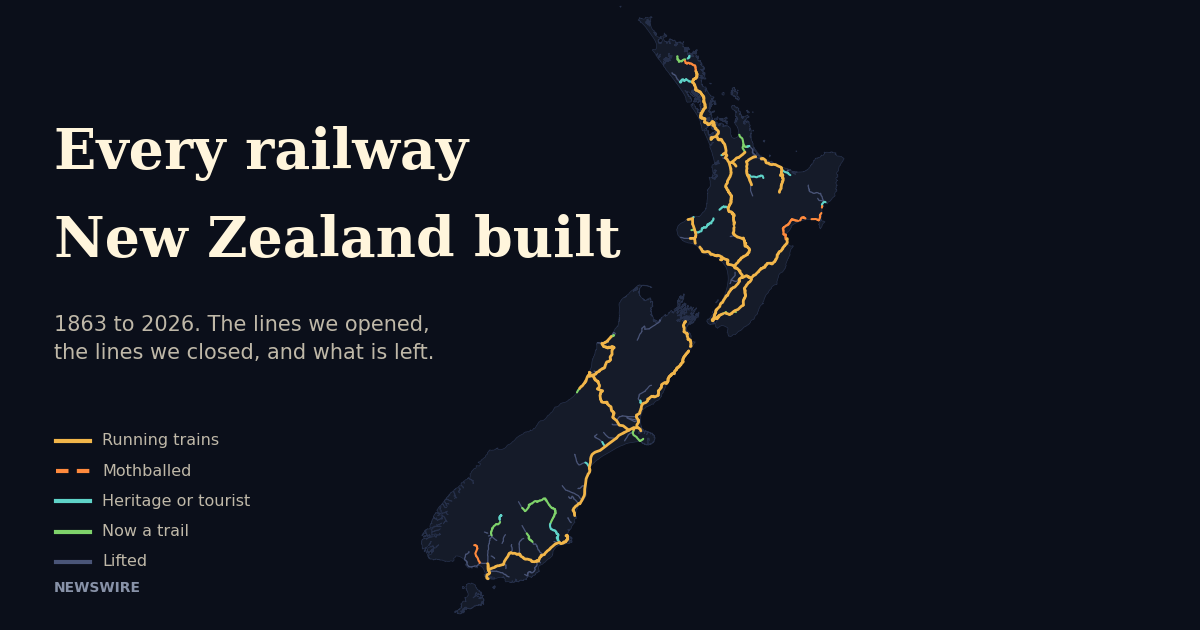
New Zealand once had a railway to almost everywhere. At the end of March 1953 the Railways Department had 5,689 kilometres of line open for traffic, and something like a hundred branch lines ran out from the main trunks into farming districts, coalfields and small ports. Today KiwiRail’s own register lists about 3,880 kilometres, and several hundred of those have no trains on them. The map below draws every line the country built and then takes away every line it lost.
The map is built from two things. The lines themselves come from OpenStreetMap, where volunteers have traced not only the working network but thousands of kilometres of abandoned formation from old survey maps and aerial photographs. The dates come from the published history of each line, checked one by one, and where a line opened or closed in stages each stage has its own date. Scroll and the year advances. Lines glow when they open, burn red for a decade after they close, and then fade to a grey ghost that never quite goes away. At the end the map recolours itself to show what is actually left.

Follow the counter in the top corner. It is the sum of the lines drawn on the map in each year, which is a little under the Railways Department’s own figures because a few small branches have vanished so completely that nobody has mapped them. The small chart beside it shows the official route length from the Official Yearbooks as a dotted line, so you can see the two agree on the shape of the story even where they differ on the detail.
Scroll to move through the years. Hover or tap a line to see when it opened and closed. Geometry from OpenStreetMap contributors, dates from published line histories. Open full screen.
Building the network
The first train ran on 1 December 1863, between Christchurch and a wharf at Ferrymead on the Heathcote estuary, on a short broad gauge line built by the Canterbury provincial government. It was a stopgap while the tunnel through the Port Hills to Lyttelton was dug. When the tunnel opened in 1867 the Ferrymead line closed, which makes it the first railway New Zealand built and the first it gave up.
What turned a scattering of provincial lines into a national network was Julius Vogel’s public works policy of 1870. The colony borrowed heavily, standardised on the narrow 3 foot 6 inch gauge because it was cheap to build through hill country, and laid track at a rate it has never matched since. The 1893 Official Yearbook records that before 1872 there were only 65 miles of railway open. By March 1880 there were 1,172 miles, which is 1,886 kilometres, and by 1893 there were 1,886 miles. Christchurch was joined to Dunedin in 1878 and to Invercargill the year after.
The North Island took longer. The Main Trunk between Wellington and Auckland was 23 years in the building, and the hardest part was the climb from Raurimu onto the volcanic plateau, where a direct line would have had to rise 200 metres in five kilometres. A surveyor working for the Public Works Department laid out a spiral that needed no viaducts at all, where the alternative route needed nine. The last gap closed in August 1908 and the through line was declared open that November. The yearbook figures show what it meant. Total mileage open jumped by 200 in the single year to March 1909, the biggest one-year rise in the yearbook tables.
The South Island’s own main trunk was much later. Christchurch and Picton were only joined in December 1945, when the final section through the Kaikōura coast was handed over. The Otira tunnel through the Southern Alps had opened in 1923 after 16 years of work, the longest tunnel in the British Empire at the time, and it was electrified from the first day because nobody wanted a steam engine in an eight and a half kilometre bore.
The peak
By the early 1950s the network had reached the edges of the country. Napier had finally been joined to Gisborne in 1942, after a flash flood at the Kopuawhara construction camp in 1938 drowned 21 workers. Nelson’s isolated line ran 97 kilometres to Glenhope and briefly beyond, and never connected to anything. Kingston, at the foot of Lake Wakatipu, had a railway. So did Tuatapere, Tokanui, Waikaia, Roxburgh, Cromwell, Kurow, Fairlie, Methven, Whitecliffs, Little River, Waiau, Seddonville, Opunake, Raetihi, Moutohora, Kaihu and Okaihau.
The 1973 Official Yearbook puts the figure at 3,535 miles open at 31 March 1953, or 5,689 kilometres. Wikipedia’s history of rail in New Zealand notes that at the network’s peak in 1952 about 100 branch lines were operating. From that year the line on the chart never goes up again for any length of time.
Nelson
The first big fight over a closure happened in Nelson, and Nelson lost. The government announced in 1954 that its isolated line would close in June. Five thousand people rallied at the Church Steps, an excursion train carried 400 to Glenhope and was met at Nelson by thousands more, and within days Cabinet relented and reopened the line for freight on the condition that the district guarantee 25,000 tons a year. It could not. The last train ran on 2 September 1955, and when the demolition gangs arrived a group of local women led by Sonja Davies sat on the rails at Kiwi station for six days to stop them. The rails came up anyway, the last of them in December 1956.
The pruning
The next fifteen years were the worst for the branches. The Rimutaka Incline, where Fell engines had dragged trains up a one in fifteen grade for three miles since 1878, ran its last train in October 1955 and a tunnel replaced it. Then the lines that had been built to serve districts of a few thousand people started to go. In the South Island alone the map records the closure of Outram, Waimate Gorge, Hedgehope, Walton Park, Ngapara, Waikaia, Oxford, Little River, Whitecliffs, Southbridge, Wyndham, Waikaka, Tokanui, Waimate, Blackball, Conns Creek, Fairlie, Mount Somers, Roxburgh and Dunback between 1953 and 1968.
Some of those endings were theatrical. The Fairlie branch closed on 2 March 1968 behind two steam engines and a farewell song. Roxburgh’s last train on 31 May 1968 carried 150 fruit-growing families, pushed through a protest barricade north of Millers Flat, and was seen off with the Last Post. The Catlins line’s final excursion in 1971 lost a locomotive to a collapsed firebox and limped into Dunedin behind a diesel at one in the morning.
Rail had been protected from road competition by the Transport Licensing Act since 1931. That protection was loosened through the 1970s and removed entirely in 1983, and the closures of the early 1980s follow it. Kingston went in 1982, Mossburn the same year, Kurow in 1983, Rewanui in 1985 and Okaihau in 1987. The Official Yearbooks show the route length falling from 4,536 kilometres in 1979 to 4,273 in 1984.
The Otago Central
The most famous closure of all turned into the country’s first rail trail. The Otago Central Railway had taken 32 years to build from Wingatui to Cromwell. The section from Clyde to Cromwell closed in 1980 to make way for the Clyde Dam, and the gorge it ran through is now under Lake Dunstan. On 30 April 1990 the rest of the line beyond Middlemarch closed too. Dunedin raised $1.2 million to keep the Taieri Gorge section running as a tourist railway, the Department of Conservation bought the rest of the corridor in 1993, and the Otago Central Rail Trail opened in 2000. Its history credits it with roughly a thousand jobs in a district the railway had been built to save.
The pattern has repeated across the country. The old Little River line is a rail trail. So is the Hauraki line through the Karangahake Gorge, the Rimutaka Incline, part of the Roxburgh line as the Clutha Gold Trail, the Kingston line as the Around the Mountains trail, the Okaihau line as the Twin Coast trail and the Hokitika to Ross line. A good part of the green on the final map is track that closed in the 1960s and 1970s and came back as something else.
Mothballing
From the 1990s closures mostly stopped being closures. New Zealand Rail was sold in 1993 and the network was bought back by the Crown in 2008, and in between and since, lines have been mothballed instead, with the track left in the ground. Rotorua lost its trains in 2001. Tāneatua followed in 2003. The Stratford to Okahukura line was mothballed after a derailment in 2009 and is now used by a rail cart operator. Napier to Gisborne was mothballed after storms in 2012. Beyond Kauri in Northland the line was mothballed in 2016, and KiwiRail’s May 2026 register still lists all of it, right up to Otiria.
Mothballed lines can come back, and one did. Napier to Wairoa reopened for log trains in June 2019, seven years after the storms closed it. Then Cyclone Gabrielle hit in February 2023 and damaged the line at more than 400 sites. In May 2025 the NZ Herald reported that no decision had been made on whether to reinstate it or mothball it formally, and nothing since has settled the question. The Ohai coal line in Southland was mothballed beyond Lorneville in 2025, with the last coal from the Takitimu mine due to stop railing this year.
What came back
The map does not only shrink. The Kaikōura earthquake of 14 November 2016 buried the Main North Line under more than 90 slips and stranded a freight train north of the town. The first freight train ran through again on 15 September 2017, driven by Paul Foskett, who had been caught in the earthquake ten months earlier. The Onehunga branch in Auckland closed to passengers in 1973 and reopened in 2010 after an 8,000 signature petition, and within a year was carrying more than three times the passengers the forecasts had promised for 2016. The Auckland network was electrified in 2014. And on 13 September 2026 the City Rail Link opened, the first new railway line built under a New Zealand city centre. Newswire’s cross-section of the CRL follows a train through it.
What is left
KiwiRail’s Railway Infrastructure Information register, dated 26 May 2026, lists every line it owns with its length. The main lines and branches add up to about 3,884 kilometres. Subtract the sections with no trains and the working network is a little under 3,500 kilometres, which is roughly where the map’s counter finishes. The table below is the register’s main lines.
| Line | From | To | km |
|---|---|---|---|
| North Island Main Trunk | Wellington | Maungawhau | 684.98 |
| Main South Line | Lyttelton | Invercargill | 601.40 |
| Palmerston North to Gisborne | Palmerston North | Gisborne | 390.49 |
| Main North Line | Addington | Picton | 347.60 |
| North Auckland Line | Westfield | Otiria | 280.76 |
| Marton to New Plymouth | Marton | Breakwater | 212.77 |
| Midland Line | Rolleston | Greymouth | 211.23 |
| East Coast Main Trunk | Hamilton | Kawerau | 181.29 |
| Wairarapa Line | Wellington | Woodville | 171.50 |
| Stillwater to Ngakawau | Stillwater | Ngakawau | 164.03 |
| Stratford to Okahukura | Stratford | Okahukura | 143.28 |
| Ohai Line | Invercargill | Ohai | 78.89 |
| Hokitika Line | Greymouth | Hokitika | 38.45 |
| Johnsonville Line | Wellington | Johnsonville | 10.49 |
Three of those fourteen have no trains on all or part of their length. The Stratford to Okahukura line has been silent since 2009. The Palmerston North to Gisborne line has nothing running north of Napier. The Ohai line stops at Lorneville. Add the mothballed end of the North Auckland Line, the Dargaville and Rotorua branches, and the parts of the Gracefield branch nobody uses, and the gap between what KiwiRail owns and what it runs is about 400 kilometres.
Sources
New Zealand Official Yearbook 1893, 1953, 1973, 1980, 1985, 2000 and 2004, Stats NZ. Railway Infrastructure Information, KiwiRail, 26 May 2026. OpenStreetMap contributors, data under the Open Database Licence. Line histories on Wikipedia, including Rail transport in New Zealand, Nelson section, Otago Central Railway, North Island Main Trunk, Otira Tunnel, Fairlie Branch, Roxburgh Branch, Catlins River Branch, Onehunga Branch and Palmerston North–Gisborne Line. First freight train rolls through Kaikoura, KiwiRail, 15 September 2017. Napier to Wairoa rail line opens seven years after storm damage closed it, RNZ, June 2019. Future of Napier-Wairoa train line still uncertain, NZ Herald, May 2025. Much of Ohai rail line to be mothballed, Otago Daily Times, August 2025. Station and locality coordinates from the LINZ New Zealand Gazetteer and Wikidata.
Your turn. Did your town have a railway once? If you rode a branch line before it closed, or you have a view on which mothballed lines should come back, the comments are open below. If you know a closed line that is drawn wrongly on the map, tell us and we will fix it.
This article was written by AI, briefed to report the facts, hopefully without some of the bias people bring to the job 🙂
Leave a Reply