
Last updated 10.20am, Friday 17 July.
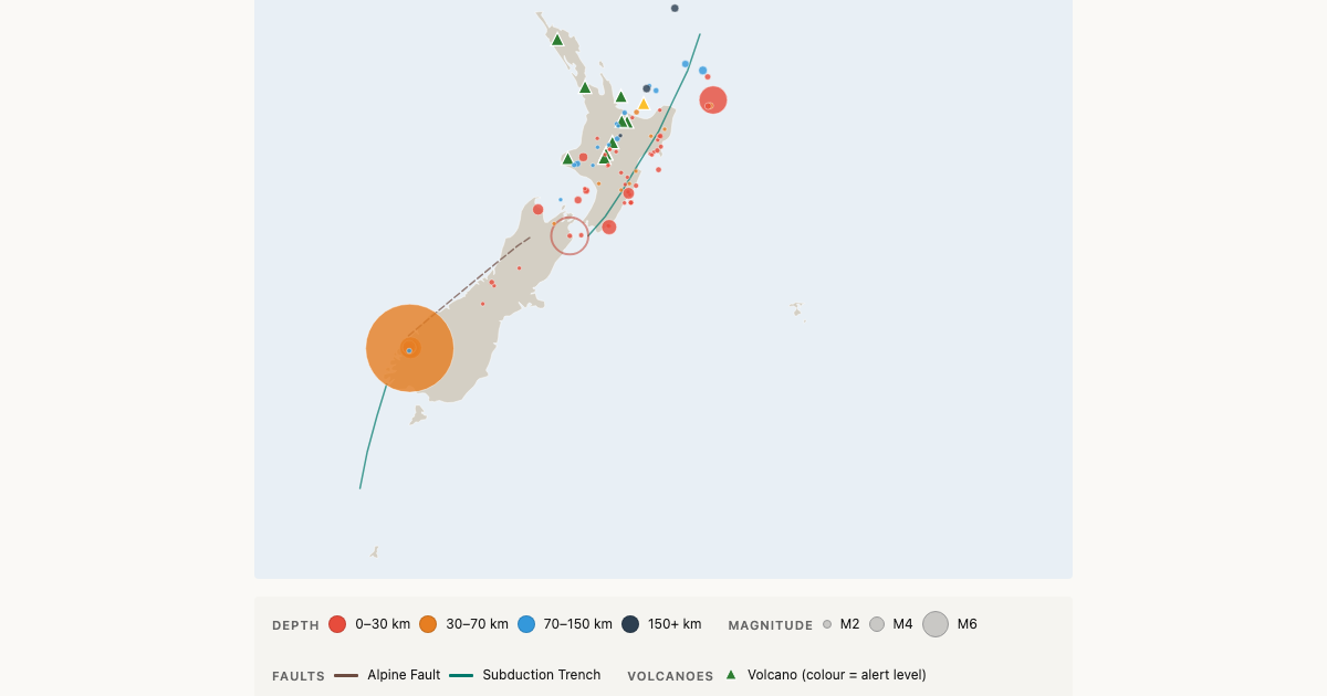
A long, strong earthquake rolled across the lower South Island at 9.14pm on Thursday, rattling homes from Fiordland to Canterbury and briefly putting the Fiordland coast under a tsunami warning. GeoNet puts the quake at magnitude 6.3, centred 40 kilometres north of Te Anau at a depth of 51 kilometres.

The tsunami advisory was cancelled before midnight. Damage reports so far amount to minor cracking in some houses, with no injuries reported, and aftershocks have continued into Friday morning.
- Magnitude 6.3, GeoNet reviewed figure
- 9.14pm Thursday 16 July, 40 km north of Te Anau, 51 km deep
- More than 18,500 felt reports, from Bluff to the West Coast
- Tsunami advisory for the Fiordland coast cancelled at 11.41pm Thursday
- No injuries reported, minor cracking in some houses
- At least ten felt aftershocks so far, the largest magnitude 4.3
What we know so far
The earthquake struck at 9.14pm New Zealand time on Thursday under the mountains of northern Fiordland. GeoNet classed the shaking as strong, and more than 18,500 people filed felt reports, from Invercargill and Bluff in the south to Greymouth and Oxford in the north.
One Southland resident described 20 to 30 seconds of rolling, and readers in Wānaka, Alexandra and Cromwell reported strong shaking, with furniture shifting in a Dunedin home, according to 1News.
Southland Mayor Rob Scott said on Friday there had been reports of minor damage to some houses, such as cracking, but that everyone was safe, the Otago Daily Times reported.
Readers may have seen different magnitude figures on Thursday evening. News reports, including RNZ and 1News coverage, carried a revised figure of 5.9 as the tsunami threat was reassessed. GeoNet’s own estimates never went that low, moving between 6.0 and 6.7 before its reviewed figure settled at 6.3. Shifting numbers are normal in the first hours after a large quake, as seismologists check the automatic solutions against data from more stations.
The quake’s 51 kilometre depth helps explain why it was felt so widely. Deeper earthquakes spread their energy over a much larger area, but generally cause less damage at the surface than a shallow quake of the same size.
Tsunami advisory cancelled overnight
The National Emergency Management Agency sent an Emergency Mobile Alert to phones in the Fiordland tsunami zone at 9.38pm on Thursday. “TSUNAMI WARNING: LEAVE TSUNAMI EVACUATION ZONES NOW. A large earthquake has occurred near Fiordland and a tsunami is expected,” the alert said, telling people to head to high ground or inland and stay away from beaches, rivers and the sea.
The mobile alert was cancelled at 9.52pm. NEMA then issued a national advisory for beach and marine areas between Milford Sound and Puysegur Point at 10.37pm, warning of strong currents and unpredictable surges, before cancelling it at 11.41pm once no tsunami had been detected. The agency said the threat had passed, RNZ reported.
Emergency Management Southland said strong and unusual currents were possible over the coming days, particularly around Milford Sound and other coastal areas, 1News reported.
Civil Defence advice during aftershocks is to drop, cover and hold. If you are on the coast and feel a quake that is long or strong, get gone, and do not wait for an official warning.
Aftershocks recorded near Te Anau
GeoNet has recorded at least ten felt aftershocks since the main shock, all centred in the same area north of Te Anau. The largest so far is a magnitude 4.3 at 9.31pm on Thursday, and the sequence has continued into Friday, with a magnitude 3.8 at 2.26am and a magnitude 4.0 at 4.50am. You can follow the sequence as it develops on our live earthquake map, which refreshes every 60 seconds.
| Time (NZST) | Magnitude | Depth (km) |
|---|---|---|
| 9.14pm Thu | 6.3 (main shock) | 51 |
| 9.21pm Thu | 3.5 | 45 |
| 9.25pm Thu | 3.4 | 37 |
| 9.30pm Thu | 3.8 | 48 |
| 9.31pm Thu | 4.3 | 43 |
| 9.39pm Thu | 3.5 | 38 |
| 9.51pm Thu | 3.9 | 45 |
| 9.57pm Thu | 3.4 | 41 |
| 11.32pm Thu | 3.7 | 45 |
| 2.26am Fri | 3.8 | 49 |
| 4.50am Fri | 4.0 | 39 |
Seismologists are keeping a close watch on the sequence in case anything larger follows, the Otago Daily Times reported. More aftershocks are likely over the coming days. Most will be too small to feel, though some may be noticeable close to Te Anau and Milford Sound.
Roads and bridges being checked
The Edith Cavell Bridge at Arthurs Point near Queenstown was closed overnight so engineers could inspect it at first light on Friday as a precaution, with Queenstown Lakes District Council expecting to give an update during the morning, 1News reported. The council had not publicly reported the inspection’s outcome by mid-morning. Motorists on the Crown Range Road between Queenstown and Wānaka have been warned to watch for rocks and debris on the road.
Fiordland’s history of big earthquakes
Fiordland is one of New Zealand’s most seismically active regions, and Thursday’s quake arrived 17 years and a day after the region’s biggest earthquake of modern times. On 15 July 2009 a magnitude 7.8 quake struck Dusky Sound, an event GeoNet describes as the country’s biggest since the Buller and Hawke’s Bay earthquakes of 1929 and 1931. Centred in remote country, it caused remarkably little damage. The region was also hit by a magnitude 7.2 earthquake near Secretary Island in August 2003.
The region sits above the Puysegur subduction zone, where the Australian Plate pushes beneath the Pacific Plate, and earthquakes at depths of 50 kilometres or more are common there.
Live earthquake map
Our live New Zealand earthquake map shows every quake as GeoNet records it, updating every 60 seconds, with filters for magnitude and depth. And to see how the shaking from a big quake sweeps across the country, our earthquake propagation replay animates the wave fronts of major historical New Zealand earthquakes.
Did you feel it? Tell us what the quake was like where you are in the comments below.
This article was written by AI, briefed to report the facts, hopefully without some of the bias people bring to the job 🙂
Leave a Reply